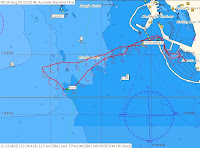
 Click on to enlarge
We reversed out of the Pen at 11:53am. The pressure was 1026 mBar and increasing, with clear skies, cool breeze on flat seas and a temperature of 15C. Conditions were near perfect for sailing. We lowered the keel, hoisted sails and were under sail. We were reaching at 60-70 TWA on a SW heading of 240degrees with full main and light heady at a speed of 7.2 knots in 8-10 knots of breeze from SSE (170-180 degrees). There was an outgoing tide at around 0.6 m with a minimum depth of 0.5 m expected at 3.28pm. We were just setting up to hoist a kite and bear away to the North when it felt like an explosion. We hit a submerged object that we presume to be rock at position 32 04.295 S 115 43.670 E at 12:08:33 hrs + 2 secs, 15 minutes after we left the pen. This about 0.8 nm SW of FSC harbor entrance about halfway between L and F mark. We hit harder than anything you can imagine. We hit once and stopped dead with nothing else felt. No bottom drag, no second hit. Watching the reply on Expedition is not enjoyable.
Analysis of the track log on the computer shows the depth gauge was reading 5.3 to 5.5m depending the exact second we hit. Whatever we hit did not register. The minimum depth shown on the sounder on our track around the area was one measurement at 4.4 m about 15 secs after we hit but was generally showing in the 5.5 - 7 m mark for the minute prior and after the incident. Chart Depth indicates 5.1m and according to the tide charts we had 0.6m of tide at the time, meaning we should have had around 5.7m which is in line with what the depth gauge was showing. And yes the depth gauge is correct, it was showing 2.7 in the pen. We draw 3.6m of water with the keel fully down and therefore should have had more than 2m below the keel.
We were reaching so there was very little heel. The point of impact looks like 200 mm from the base of the bulb therefore we hit an object that is at a water depth of around (3.4-0.6) 2.8 m Datum height. There is definitely no indication of any obstruction near this depth in this area marked on any chart. I have checked paper charts, CMaps, and Mapsource. Some charts suggest 3.7 near this area but with 0.5 we are still at 4.2m. There are rumours of old tall ship moorings in this area but we suspect a bit of reef sticking up here as anything else would have been destroyed with the impact 12 tonne at 7.5 knots coming to a dead stop. The lead on the bulb has been shortened by around 100mm and peeled back.
Nav was at the back of the boat and went flying into the wheel on the port side badly bruising a knee and chest and losing consciousness for a moment after being winded. My glasses ended up near the hatch and were smashed to pieces such was the force. The skipper flew through the air ending up near the hatchway. Another crewman nearly lost his head with a cut neck after flying into the hatch. Another was down below and flew the length of the galley. Another badly bruised his thigh against the winch. But overall everyone seems okay with just bruises and broken souls. We were lucky no one was seriously injured.
Once we recovered from the shock we removed some floor panels and could see some water running in so we knew it was serious. We immediately rang Fremantle to start organizing the tammy lift ready for us while we lowered sails, started the motor and headed home. We were at the jetty at 12:21pm around 13 minutes after the incident and on the tammy lift shortly thereafter. The hydraulic keel lifted without any issues to full height for marina entry. The keel pin was inserted prior to the lift.
The boat was taking on water we estimate at about 20Litres per minute and got to about 3 inches in the bilge by the time we got the boat out of the water. We had the manual bilge pumping as well as the auto bilge pumps.
Here is a couple of downloads of our track showing where we hit, near L mark. We hit where I have marked “rock”. We have sailed within 10-20 metres of this spot many time before without any hint of a problem and previous log data shows the depth in this area to be 5-7 metres.
The harbourmaster and DPI have stated they will be surveying the area to find out what we hit.
The front of the keel is flat and the bulb has shunted on the skeg. There is damage to the carbon under the floor at the base of the keel. We cannot see any damage anywhere else. We will just have to wait and see. Could be a while before we are back on the water. I think I need therapy to get over this one.